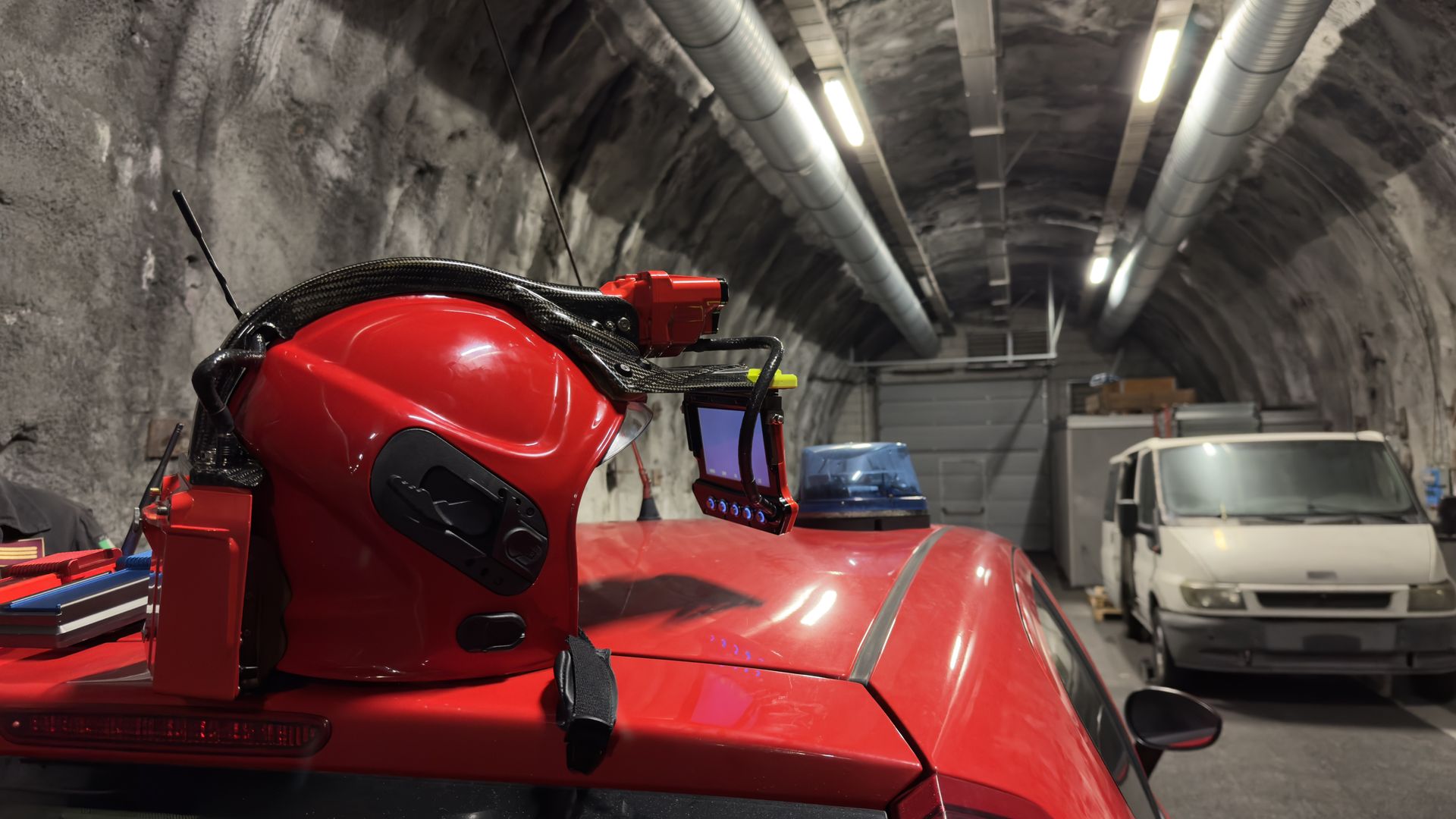
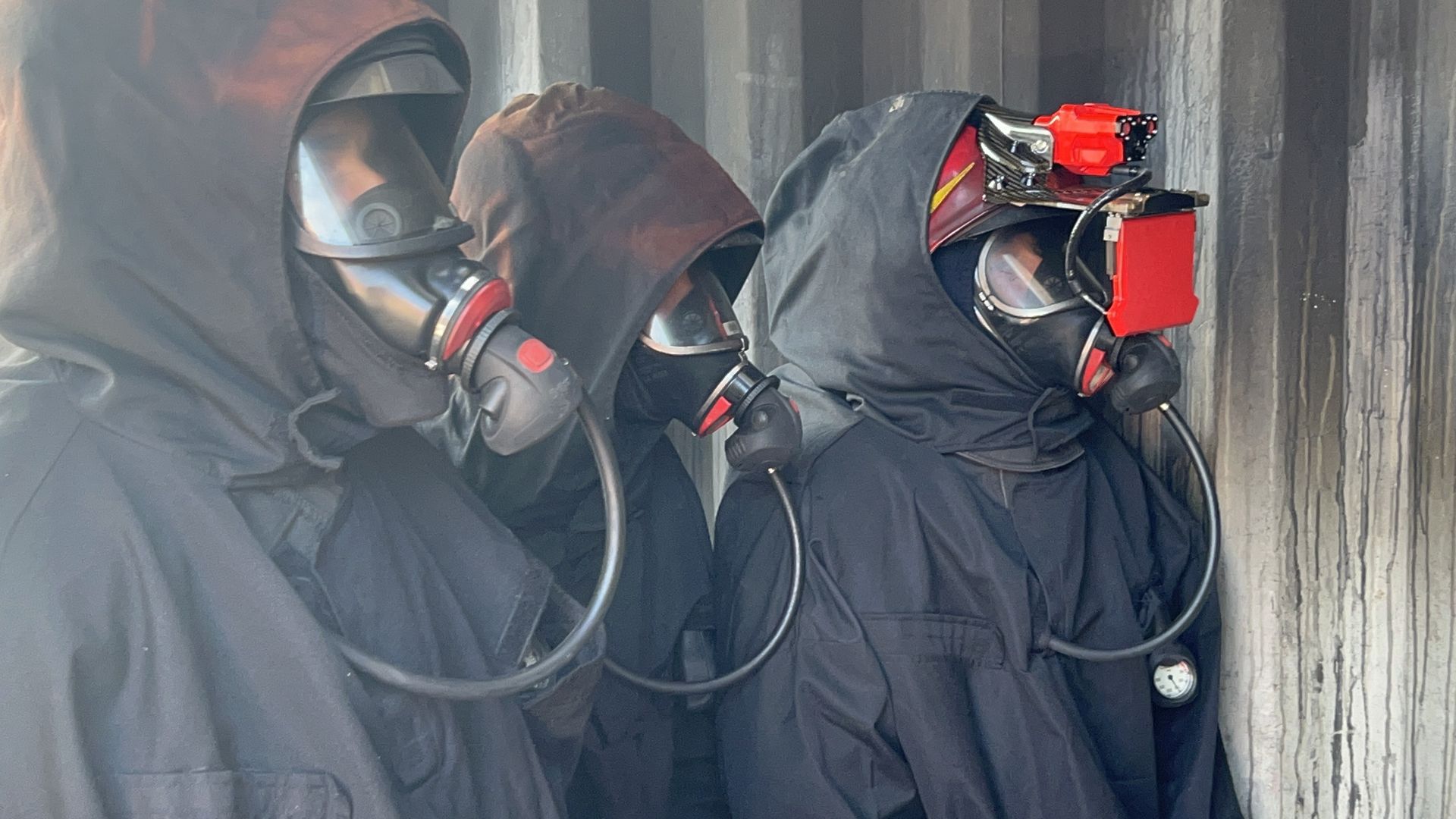
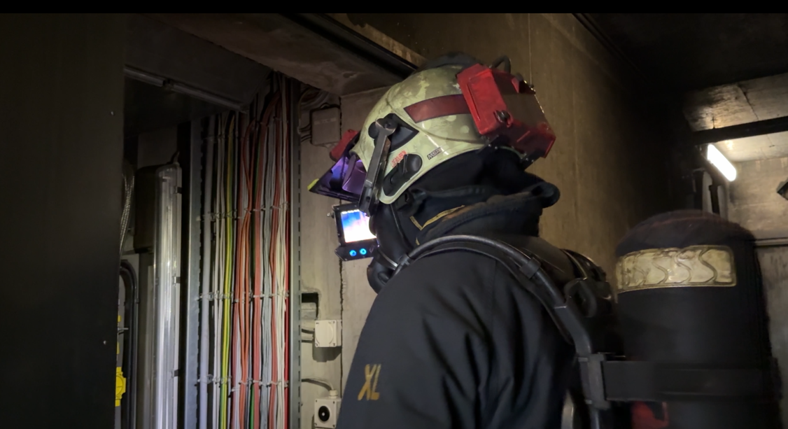
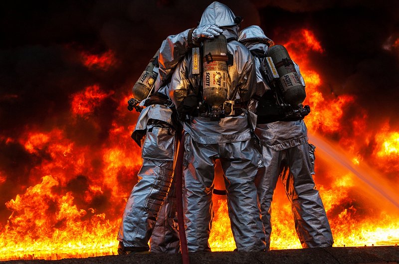
iFalconHM Applications
The iFalconHM helmet-mounted thermal camera system adapts to a wide range of critical situations, providing enhanced visibility and communication where they matter most. Its versatility makes it an essential tool for professionals operating in extreme and unpredictable environments.
Railway, highway
& tunnels Mine search
& rescue Riot management & containment High return facilities Wide areas coordination Long Range Night Vision
Mine search & rescueMine search & rescue
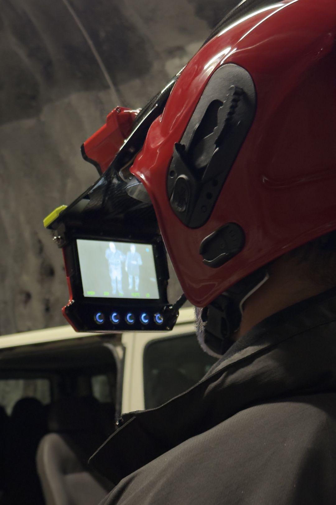
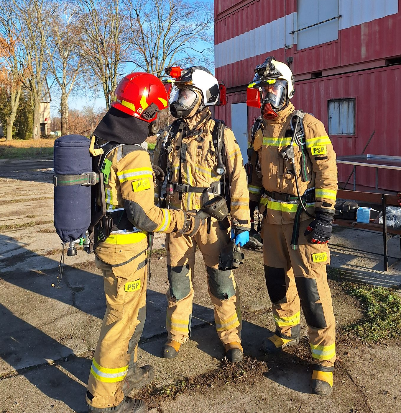
Firefighter and rescue team safety is a top priority in these hazardous environments. iFalconHM enables real-time tracking of team members, ensuring better coordination and safer operations. This is particularly crucial in tunnels, where exits may be far apart, and escape routes need to be carefully managed.
For infrastructure protection, thermal imaging helps detect hot spots early, allowing firefighters to contain fires before they cause severe damage to railway tracks, tunnel structures, or highway installations. This rapid response minimizes disruptions and prevents costly structural failures.
In tunnels and other enclosed spaces, wireless real-time video transmission is a game-changer. Command centers can monitor the incident remotely, providing firefighters with up-to-date information for better coordination and decision-making. This is especially useful in long tunnels or highway incidents where traditional communication may be compromised.
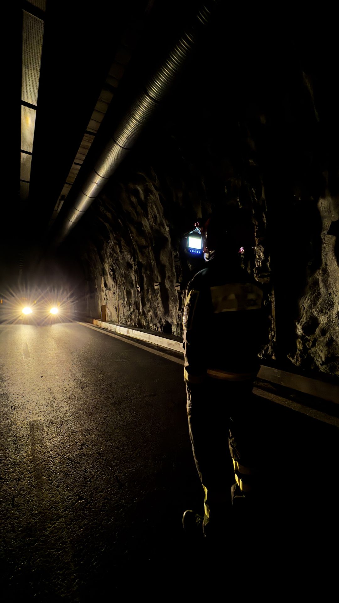
Navigating railway networks, highways, and tunnels during an emergency can be extremely challenging. iFalconHM improves visibility and orientation, helping responders move efficiently through complex or obstructed areas, reducing the risk of disorientation.
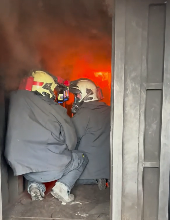
The iFalconHM system offers critical advantages in fire emergencies occurring on railways, highways, and tunnels, where visibility, communication, and rapid response are essential.
Fires in these environments often generate thick smoke and extreme heat, making navigation dangerous. iFalconHM’s thermal imaging allows firefighters and rescue teams to see through smoke, quickly identifying fire sources, trapped individuals, and structural hazards. This enhances situational awareness and speeds up rescue operations.
Railway, highway & tunnels
In areas that are dark and challenging for rescue teams to reach, navigation and environmental recognition can be quite difficult. Emergency responders operating underground may struggle to orient themselves in low-light or dusty conditions.
With iFalconHM, it is possible to rescue as many casualties as possible in highly challenging and dangerous environments, where swift action is critical. Rescuers can communicate effectively even when out of sight of one another, thanks to the integrated communication network, and can locate victims more easily using thermal imaging technology.
Mine search & rescue
Mine search and rescue is an incredibly challenging job. Locating and rescuing miners trapped deep underground in life-threatening situations necessitates specialized equipment. The conditions in which miners find themselves are often harsh, making conventional tools ineffective. Mines are typically dark, with narrow passageways that can be extremely difficult to navigate, particularly following incidents such as gas explosions, coal dust blasts, gas and rock outbursts, and underground fires.
iFalconHM is the ideal solution for life-threatening situations involving miners, where it is crucial to quickly locate casualties and provide rapid medical assistance.
Rescuers operating in tunnels or mines will have no trouble navigating through dimly lit or smoke-filled conditions while equipped with a self-contained breathing apparatus (SCBA). With iFalconHM, it becomes possible to maximize victim recovery efforts in these challenging and hazardous environments.
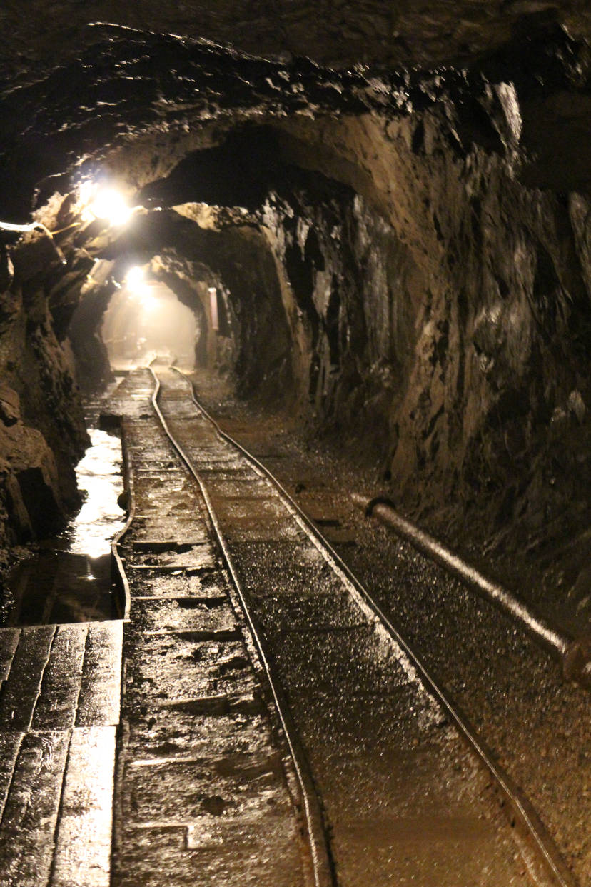
The iFalconHM system can play a vital role in mine search and rescue operations, where low visibility, hazardous environments, and communication challenges make rescues extremely difficult.
Mines are often filled with dust, smoke, and total darkness during emergencies, making it nearly impossible for rescuers to navigate. iFalconHM’s thermal imaging allows teams to see through these conditions, quickly identifying trapped miners, fire sources, or structural hazards. This improves rescue speed and efficiency.
One of the biggest challenges in underground rescues is communication. With wireless real-time video transmission, command centers can monitor the situation remotely, guiding teams through the mine with up-to-date information. This is essential in deep or complex mining tunnels where radio signals may not always be reliable.
Mines have intricate and extensive tunnel networks, which can be disorienting, especially in emergency conditions. iFalconHM helps rescuers navigate efficiently, reducing the risk of getting lost or trapped and allowing for more strategic deployment of resources.
Rescuer safety is a top priority in such hazardous environments. Real-time location tracking ensures better coordination, helping teams avoid dangerous areas while staying connected. This is crucial in collapsed or partially blocked tunnels, where movement needs to be carefully planned.
Early detection of hot spots or trapped individuals using thermal imaging helps responders prioritize rescue efforts, preventing further collapses or secondary hazards. By identifying dangers before they escalate, iFalconHM helps protect both victims and rescuers, increasing the chances of a successful operation.

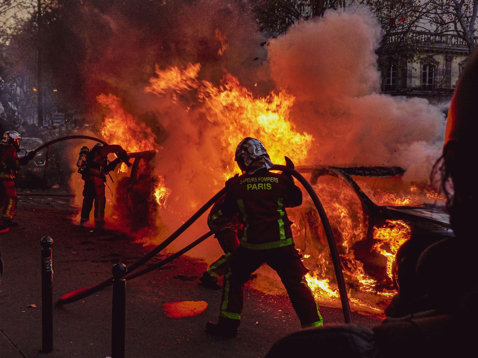
Riot management and containment
Riots are extremely problematic to control, as they may require not only firefighting but also interaction with the outraged crowd. Riot management operations require free hands to contain the situation as smoothly as possible.
With iFalconHM, the operations coordinator can thoroughly assess the situation and respond more swiftly, thanks to real-time remote video capabilities. The geo-localization of each operator enables a coordinated response from public security officers, allowing for rapid intervention in dangerous situations and minimizing risk for everyone involved.
The iFalconHM system is a powerful tool for riot management and containment, where visibility, coordination, and real-time communication are crucial for maintaining order and ensuring safety.
In chaotic and fast-moving situations, low visibility due to smoke, tear gas, or nighttime conditions can make it difficult for security forces to assess the situation. iFalconHM’s thermal imaging allows teams to see through these obstacles, identifying individuals, gathering crowds, and spotting potential threats even in complete darkness.
Effective riot containment requires real-time coordination between different units. With wireless video transmission, command centers can monitor officers on the ground, track movements of crowds, and adjust strategies accordingly. This ensures a more controlled and organized response, preventing escalation.
Navigating through dense crowds and urban environments can be challenging, especially during violent demonstrations. iFalconHM enhances situational awareness, helping security forces move strategically, avoid bottlenecks, and block escape routes when necessary.
Officer safety is a top priority in riot situations. Real-time tracking allows commanders to monitor team positions, ensuring that units remain connected and do not become isolated. This also helps in quickly deploying reinforcements where needed.
By using thermal imaging to detect crowd movements and potential threats, iFalconHM enables a proactive approach to riot control. Identifying high-risk areas and individuals early helps security forces intervene before violence escalates, leading to more effective and controlled containment.
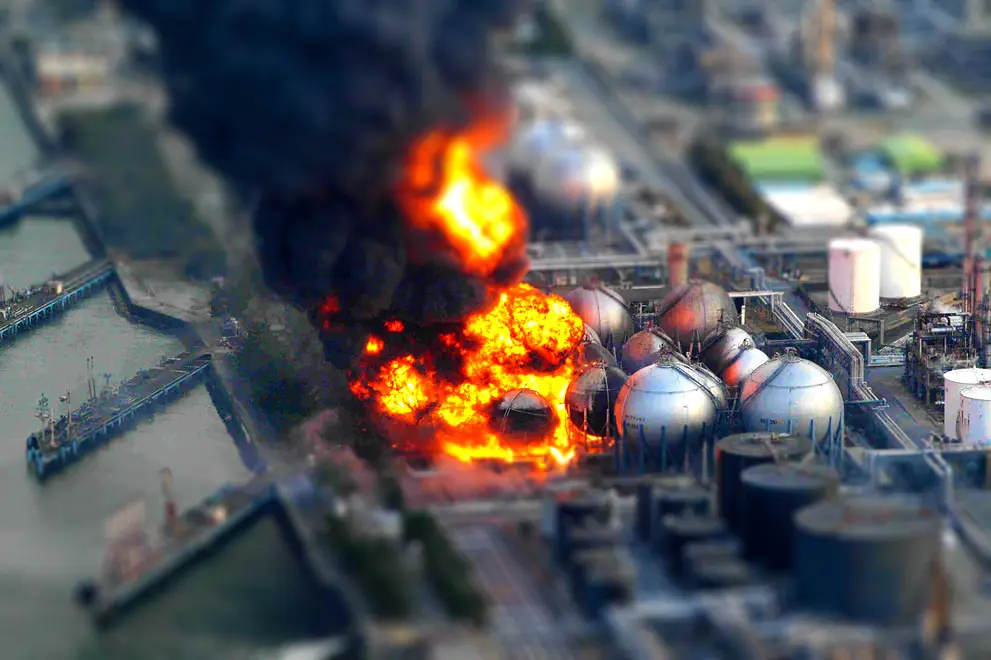
High return facilities
In energy production industries, like missile plant storage and nuclear plants, rescuers benefit from simultaneous and real-time multiple views of the intervention area(s) as well as geo - localization of each rescuer in the area, generating faster and more coordinated actions for effective disaster containment.
Luoghi come questi sono particolarmente a rischio di incendi o esplosioni a causa del tipo di attività che svolgono. I siti ad alto rischio, come gli impianti petroliferi o la produzione di petrolio, richiedono un intervento rapido per ridurre i rischi potenziali come esplosioni e incendi di grandi dimensioni.
Utilizzando iFalconHM nelle aree in cui sono presenti prodotti di alto valore, è possibile salvare il maggior numero possibile di asset.
The system also enables real-time wireless video transmission, allowing incident commanders to assess the situation remotely. With live visual data, they can make faster and more informed decisions about firefighting strategies and personnel movements.
High-value facilities often have large and complex layouts, making navigation difficult, especially in emergencies. iFalconHM helps firefighters move efficiently through unfamiliar spaces, reducing the risk of getting lost or trapped.
Firefighter safety is another critical benefit. By providing real-time location awareness, iFalconHM helps teams stay connected and coordinated, ensuring safer exits, better rescue operations, and more effective tactical adjustments.
In facilities housing sensitive or high-value equipment, targeted firefighting is essential to minimize damage. Early detection of hot spots with thermal imaging allows teams to contain fires before they spread to critical infrastructure, protecting valuable assets and preventing catastrophic losses.
The iFalconHM system can provide crucial advantages during fires in high-return facilities such as data centers, manufacturing plants, and warehouses storing valuable goods.
Fires in these environments often produce thick smoke, making visibility almost zero. iFalconHM's thermal imaging allows firefighters to see through smoke, helping them locate fire sources, trapped individuals, and potential hazards. This improves situational awareness and speeds up rescue efforts.
Wide areas coordination
Emergency situations occurring over large areas are very difficult to manage. Coordinating operations is challenging when rescuers are far from each other and communication is compromised.
Wildfires spread very quickly and require speed of action to prevent the spread of fire. In case of forest fire, rescuers using iFalconHM can benefit from geo-localization and simultaneous viewing capabilities, which enhance coordination during interventions across extensive areas. This technology allows for the sharing of vital video footage and information, facilitating more effective response efforts.
The iFalconHM system is highly effective for wide-area coordination, where large spaces, multiple teams, and challenging conditions require seamless communication and visibility.
In large-scale incidents such as wildfires, industrial disasters, or search and rescue operations, maintaining situational awareness across vast areas is critical. iFalconHM’s thermal imaging allows teams to detect heat sources, locate individuals, and assess hazards even in smoke-filled or low-visibility conditions.
Effective coordination across wide areas depends on real-time information sharing. With wireless video transmission, command centers can monitor multiple teams simultaneously, ensuring a coordinated response. This allows for better resource allocation, reducing delays and improving overall efficiency.
Navigating open fields, industrial zones, or disaster-affected areas can be difficult, especially at night or in hazardous conditions. iFalconHM helps responders move efficiently, minimizing confusion and ensuring they reach critical locations as quickly as possible.
Team safety is a top priority when operating over large areas. Real-time tracking of personnel enables better coordination, ensuring no one gets lost or stranded in dangerous zones. This is especially important in fast-moving situations, such as wildfires or large-scale evacuations.
By using thermal imaging to detect hot spots, survivors, or potential hazards, iFalconHM helps teams focus their efforts where they are needed most. This targeted approach improves response times and maximizes efficiency, making it an invaluable tool for emergency management across wide areas.
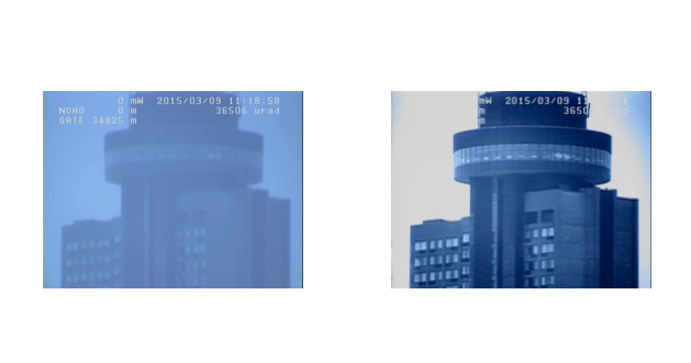
Long Range Night Vision
Long Range Night Vision systems allow monitoring activities by ensuring leading-class long-range accuracy.
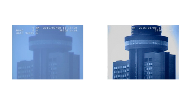
It's a breakthrough technology that provides superior identification and recognition capabilities compared to the best thermal imager. Long Range Night Vision produces remarkably detailed images over unprecedented distances.
Per raccogliere il maggior numero di informazioni possibile, un sistema di sorveglianza notturna deve essere in grado di produrre immagini ad alta risoluzione, in tempo reale, che mostrino le proprietà riflettenti di vernici, materiali e, idealmente, vedano attraverso il vetro per un'osservazione completa. Inoltre, queste immagini devono essere una firma rappresentativa dell'oggetto osservato, idealmente simile all'immagine diurna e non influenzata da diverse condizioni di temperatura.
Write something...
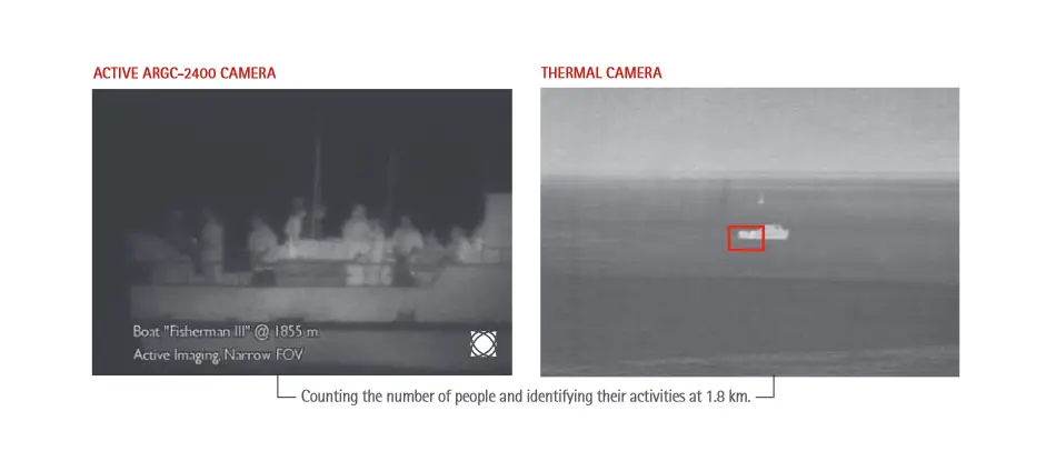
Coastal & Border control
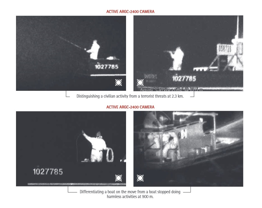
The rise of terrorist threats and escalating piracy in difficult-to-monitor waterways are heightening concerns about crew safety and potential cargo losses. One effective solution is the implementation of perimeter awareness measures onboard, such as long-range night vision cameras, which enable earlier detection of threats even in low visibility conditions.
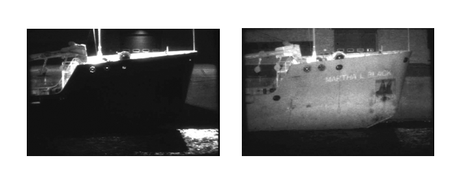
This capability facilitates more efficient border control. Additionally, the surge in refugees, illegal immigration, and smuggling is prompting governments to enhance their coastal and border surveillance programs. Many open borders are currently being reevaluated, with several European countries intensifying security along hundreds of kilometers of borders and coastlines. As a result, systematic measures for closer surveillance are being put into place.
Il sistema viene utilizzato anche per la sorveglianza ambientale volta a ridurre il trasporto illegale di petrolio e materiali tossici. Inoltre, può essere utilizzato nei programmi antidroga, nelle operazioni di ricerca e salvataggio e per identificare la pesca illegale.
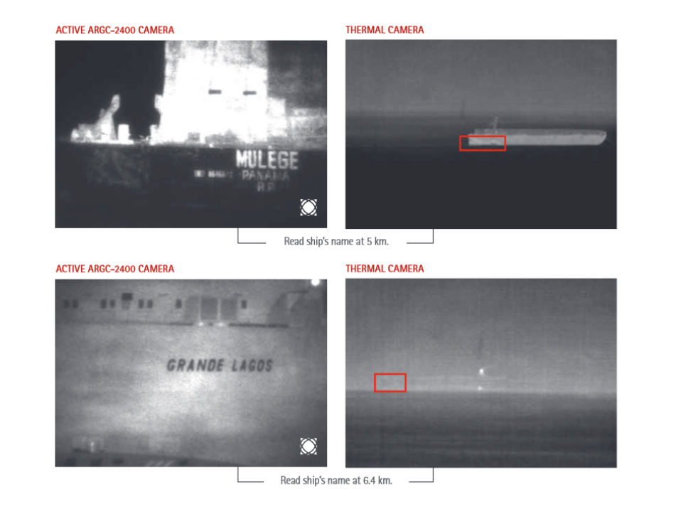
Vessel Traffic Services site protection
Advanced security criteria now require a visual confirmation of the number of people declared by the crew. It is equally important to identify those on board, monitor their activities, and assess whether the personnel on the bridge appear to be under duress. In today's world, surveillance solutions must include the capability to observe if people or specific cargo are being transferred between a ship and a small craft, such as a zodiac, or if goods are being illegally discarded overboard.
L' Assistenza al Traffico Marittimo (Vessel Traffic Service - VTS) è un sistema, simile al controllo del traffico aereo, di monitoraggio del traffico marittimo istituito dalle autorità portuali. È un servizio realizzato da un'autorità competente per migliorare la sicurezza e l'efficienza del traffico navale e per salvaguardare l'ambiente. I sistemi tipici utilizzano radar, televisione a circuito chiuso, radiotelefonia VHF e meccanismi di identificazione automatica per tenere traccia dei movimenti delle imbarcazioni e garantire la sicurezza della navigazione in una zona geografica delimitata.
Protezione del sito dei servizi di traffico navale
I criteri di sicurezza avanzati richiedono ora una conferma visiva del numero di persone dichiarate dall'equipaggio. È anche importante identificare le persone a bordo e vedere cosa stanno facendo, nonché se il personale sul ponte sembra sotto costrizione. Al giorno d'oggi, le soluzioni di sorveglianza devono offrire la possibilità di vedere se persone o determinate merci vengono trasferite tra una nave e una piccola imbarcazione come uno zodiaco o se le merci vengono semplicemente gettate in mare.
Controllo delle coste e delle frontiere
Le minacce terroristiche e la sempre crescente pirateria concentrate nei corsi d'acqua più difficili da monitorare aumentano le preoccupazioni riguardanti la sopravvivenza dell'equipaggio e la perdita del carico. La soluzione ideale è dunque l'attuazione di misure di awareness perimetrale a bordo delle imbarcazioni in modo da identificare le minacce in tempo utile, persino in condizioni di scarsa visibilità, e quindi permettendo un controllo più semplicedei confini.
Ciò consente un controllo più semplice delle frontiere. Un’ondata di rifugiati, immigrazione illegale e traffico di esseri umani stanno incoraggiando i governi a rafforzare i programmi di sorveglianza delle coste e delle frontiere. Molte frontiere aperte sono attualmente in fase di revisione. Alcuni paesi europei stanno rafforzando la protezione lungo centinaia di chilometri di confini e coste, attuando misure sistematiche per una più stretta sorveglianza.
Viene utilizzato anche per la sorveglianza ambientale volta a ridurre il trasporto di petrolio illegale e materiali tossici. Può essere utilizzato anche nei programmi antidroga, nelle operazioni di ricerca e salvataggio e per identificare la pesca illegale.
Visione notturna a lungo raggio
I sistemi di visione notturna a lungo raggio consentono il monitoraggio delle attività garantendo una precisione a lungo raggio di prima classe.
Si tratta di una tecnologia innovativa che fornisce capacità di identificazione e riconoscimento superiori rispetto alla migliore termocamera. La visione notturna a lungo raggio produce immagini straordinariamente dettagliate su distanze senza precedenti.
Per raccogliere quante più informazioni possibili, un sistema di sorveglianza notturna deve essere in grado di fornire immagini ad alta risoluzione e in tempo reale che forniscano le proprietà riflettenti della vernice, dei materiali e, idealmente, la visione attraverso il vetro per un'osservazione completa. Inoltre, queste immagini devono essere una firma rappresentativa dell'oggetto osservato, idealmente simile al giorno e non influenzato da diverse condizioni di temperatura.
Un servizio di traffico navale è un sistema di monitoraggio del traffico marittimo istituito dalle autorità portuali o portuali, simile al controllo del traffico aereo per gli aeromobili. È un servizio attuato da un'autorità competente volto a migliorare la sicurezza e l'efficienza del traffico navale e a tutelare l'ambiente. I tipici sistemi di servizio del traffico navale utilizzano radar, televisione a circuito chiuso, radiotelefonia VHF e sistemi di identificazione automatica per tenere traccia dei movimenti delle navi e garantire la sicurezza della navigazione in un'area geografica limitata.